Determination of AMSL flight height
Q: How does drone determine its current AMSL height?
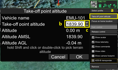
AMSL is determined according to the terrain data at the current location in combination with data given by the drone’s barometer or GPS unit (depending on the type of drone and configuration). There may be some inconsistencies where the terrain height changes very quickly. Use the Take-off point altitude function in UgCS to set the Take-off height correctly.

Take-off altitude is the altitude above mean sea level that is used by autopilot to calculate altitude. For Ardupilot it sets automatically after Home Point selection. For others, it sets to an altitude below Home Point when the mission uploads to the disarmed vehicle. In other cases, it can be set manually.
Note: it is highly recommended to always check altitude values. Altitude drift problems cannot be solved by software only and require operator attention. Always check, after power cycling a vehicle or mission upload, whether the altitude is reported correctly. UgCS tries to detect such conditions and issues a warning “It looks as if you have to power on/off your drone in order to reset barometer...” if the RAW altitude reported by the vehicle is very different from 0 at the time of mission upload.
Updated over 1 year ago
